PrologueFrankfurt, 6 January 1912
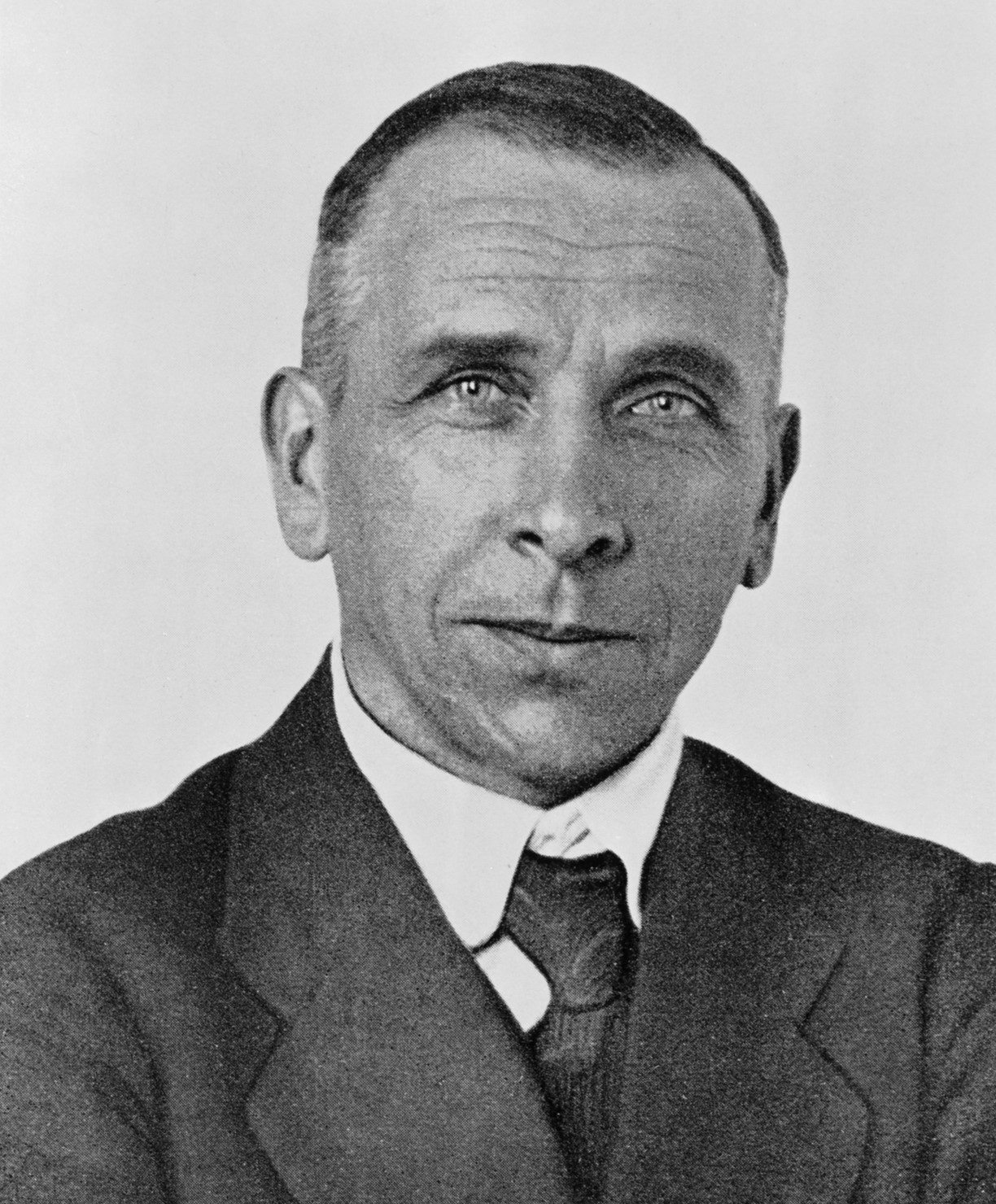
On 6 January 1912, in Frankfurt, Germany, a 31-year-old meteorologist stepped up to a lectern, faced a room full of geologists, and said something that sounded absurd at the time: the continents beneath our feet move.[9]
His name was Alfred Wegener. He was not a geologist; he studied weather and the polar regions. He said the east coast of South America and the west coast of Africa fit together like two pieces of a jigsaw; he said the continents had once been joined in a single supercontinent he called Pangaea, which began to break apart and drift some 200 million years ago.[3]
The reaction in the room was predictable. An outsider, armed with other people's data, claiming that the ground itself was on the move. This essay is not really about geology. It is about how a group of clever people treats an idea that happens to be right: first they laugh at it, then they forget it, and finally, confronted with evidence gathered by others, they have no choice but to invite it back.
Chapter OneThe Jigsaw: Coastlines, Fossils and Glaciers
Wegener's starting point was not the field. It was a library. He read the geological literature of many countries and found that if the continents had moved, a host of unrelated puzzles would all dissolve at once.
The first piece was the coastline. The east coast of South America and the west coast of Africa fit like interlocking pieces, and later measurements showed the match is tighter still when the edge of the continental shelf, 500 metres down, is used instead of the shoreline.[6]
The second piece was fossils. Mesosaurus was a freshwater reptile of about 270 million years ago whose fossils are found only in Brazil and South Africa; a freshwater animal cannot swim across the Atlantic, so the only explanation is that the two lands were one when it lived.[6] The seed fern Glossopteris left leaf fossils across South America, Africa, Madagascar, Antarctica, India and Australia, and the land reptiles Cynognathus and Lystrosaurus are likewise found only on continents now separated by oceans.[7] Plotted on a modern map, these fossil sites are scattered islands; fit the continents back together and they join into continuous bands.
The third piece was ice. Traces of glaciers from the Carboniferous to the Permian, about 300 million years ago, appear in what are now South America, Africa, India, Australia and Antarctica, many of them places that sit in the tropics today.[6] Glaciers do not walk on the equator, unless those places were never on the equator at all.
The fourth piece was mountains. The Appalachians of North America and the Caledonian mountains of Scotland are the same age, with matching rock layers, as if a single mountain chain had been cut in half by the Atlantic.[6]
Each line of evidence stood on its own, drawn from a different discipline, yet all of them pointed at the same map. Wegener's method was synthesis: an outsider who had read everyone's papers and found that every riddle had the same answer. The problem was that he had no engine.
Chapter TwoA Theory Without an Engine
A theory can hold a full hand of evidence and still be sentenced to death, because it cannot answer one question: what force moves it?
Wegener's answer was the pole-fleeing force of the Earth's rotation and the tidal pull of the Sun and Moon. In 1924 the British geophysicist Harold Jeffreys did the sums: rock is far too strong for continents to plough through the ocean floor, and the forces Wegener invoked were not even a fraction of what would be needed.[9] His physics was right. In the way Wegener imagined it, the continents could not move at all.
In 1926 the American Association of Petroleum Geologists devoted a symposium in New York to continental drift. The critics dominated, and one of them mocked the hypothesis as too "footloose", taking too many liberties with the globe.[9] By 1930 the theory had been rejected by most geologists.[3]
In November of that same year, Wegener died on the Greenland ice cap, aged 50. He had been leading a team hauling supplies to colleagues camped on the ice, and he collapsed on the way back; his theory was buried in the ice with him.[2] In 1931 the British geologist Arthur Holmes proposed that convection currents in the mantle could carry the continents along, but almost no one paid attention.[9]
The lesson of this chapter is not that the crowd was stupid. The critics held a genuine problem in physics, and Wegener was wrong about the mechanism, not about the pattern. There was a deeper layer still, a matter of method: American geology of the day prized local fieldwork and distrusted grand syntheses, especially one assembled by a meteorologist out of other people's data.[9] For a theory to survive, being right was not enough. It also had to be right in the manner the profession then approved.
Chapter ThreeThe Barcode on the Seafloor
The evidence that turned the case around did not come from the debating chamber. It came from the seafloor.
After the Second World War, echo-sounding technology developed for navies passed into civilian hands, and oceanographers began to see the ocean floor for the first time. In the 1950s the seafloor maps drawn by Bruce Heezen and Marie Tharp revealed a system of mid-ocean ridges encircling the globe, and in 1960 Heezen introduced this submarine mountain range to the public in Scientific American.[1]
In 1960 Harry Hess of Princeton proposed seafloor spreading: new oceanic crust is created continuously at the mid-ocean ridges and pushed outward on both sides, while old crust sinks back into the mantle at the trenches. The paper first circulated as a preprint and was formally published in 1962.[1]
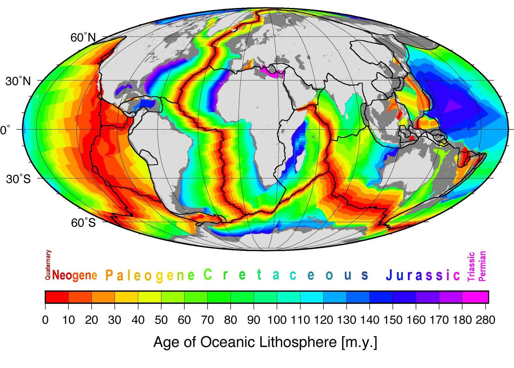
The decisive evidence appeared in Nature on 7 September 1963. Frederick Vine and Drummond Matthews of Cambridge argued that seafloor basalt records the direction of the Earth's magnetic field like a tape recorder: the moment magma cools and solidifies, grains of magnetite lock in the field's direction at that instant, and the Earth's field reverses from time to time, most recently 780,000 years ago.[4] The result was a barcode of alternating magnetic stripes, symmetrical about the ridge axis, with the rock growing older the farther it lies from the ridge.[4] Lawrence Morley of Canada had reached the same idea independently, but his papers were rejected by both Nature and the Journal of Geophysical Research as too speculative.[5]
The stripes mattered because they wrote time into rock. The seafloor was no longer an ancient, unchanging floor but a conveyor belt in constant motion, and the oldest oceanic crust is only about 180 to 200 million years old, far younger than rocks billions of years old on land.[4] Deep-sea drilling later confirmed it all.
In April 1967, Jason Morgan of Princeton presented a complete account of plate tectonics at a meeting of the American Geophysical Union, and in December of that year Dan McKenzie and Robert Parker of Cambridge published, in Nature, a paper describing the rigid motion of plates with Euler's theorem.[10] Thirty-seven years after Wegener's death, his pattern had returned, fitted with an entirely new engine.
Chapter FourThree Boundaries, One History of the World
Plate tectonics has only three kinds of boundary, yet they write almost the whole story of the Earth's surface.
At divergent boundaries, plates move apart and new crust is born at the mid-ocean ridges. The Atlantic widens by about 2.5 centimetres a year, and the spreading rate at the mid-ocean ridges runs at about 2 to 5 centimetres a year.[1] Iceland sits astride the Mid-Atlantic Ridge, torn a little wider every year, and the East African Rift is a divergent boundary on land, where Africa is slowly splitting apart.
At convergent boundaries, plates collide and one dives beneath the other, so old crust is recycled at the trenches. The Indian Plate driving north into Eurasia raised the Himalayas, and the convergent margin along the eastern Pacific built the Andes and the Cascade volcanic chain of North America.[1]
At transform boundaries, plates grind horizontally past each other, creating no crust and destroying none, only storing stress. The San Andreas Fault in California is the boundary between the Pacific and North American Plates, the two sides sliding past one another at several centimetres a year.[1]
The full picture of the speeds is more startling still. The Pacific Plate moves northwest at 7 to 11 centimetres a year; Australia moves north at about 7 centimetres a year, one of the fastest-moving continents; and the East Pacific Rise near Easter Island spreads at more than 15 centimetres a year, the fastest seafloor spreading on the planet.[1]
Geologists today divide the lithosphere into 7 major plates and many smaller ones.[1] The interior of a plate is rigid and hardly deforms; all the drama happens at the edges. That was the key insight McKenzie and Parker published in 1967: treat plates as rigid bodies, and their motion can be worked out with geometry.[10] Put the three boundaries together and the Earth gains a new map: oceans are born at the ridges and die at the trenches, and continents are merely passengers riding on the plates as they drift.
Chapter FiveThe Ring of Fire: Living on the Edge
Earthquakes and volcanoes are never random. They have addresses, and every address is written on the same map.
About 75 percent of the world's active volcanoes and about 80 percent of its earthquakes are concentrated in the Ring of Fire around the Pacific, the ring where the Pacific Plate meets the plates around it.[8]
Each kind of boundary gives disaster its own character. Earthquakes at divergent boundaries are shallow, mostly within 30 kilometres of the surface, and moderate in size; the subduction zones at convergent boundaries produce the deepest and strongest earthquakes; transform boundaries shake often and shallowly, but almost never produce volcanoes.[1]
In 1976 a magnitude 7.7 earthquake struck Tangshan, China, and the United States Geological Survey records that the death toll may have reached 800,000.[1] Plate tectonics has not made earthquakes predictable, but it has given disaster an address: once we know where the danger lives, a city can decide how to build its houses and where to retreat.
Taiwan sits squarely on such a boundary. The Philippine Sea Plate meets the Eurasian Plate here, and every tremor on the island is the sound of this map turning another page. At this point science completed a change of role: it no longer merely explains the past; it marks out, for the living, where the danger is.
EpilogueThe Ground Beneath Us Is Still Moving
Looking back over those 50 years, the turning point was not the outcome of a debate. Wegener's critics did not lose on intelligence: their physics was right and their premise was wrong, that the seafloor does not move. Wegener was not entirely right either: his mechanism was wrong and his pattern was right. What decided the case was evidence from outside the debating chamber, the barcode on the seafloor brought back by oceanographers and specialists in magnetism.
The most stubborn errors in the history of science are often not wrong answers but premises everyone has quietly agreed to. Once everyone agrees that the seafloor does not move, no number of fossils can prove that the continents are moving now; they can only prove that the continents were once joined.
Today satellites measure the position of the continents every day. The ground beneath our feet is moving slowly and steadily, at about the speed at which a fingernail grows, and the Atlantic widens by about 2.5 centimetres a year.[1] Wegener did not live to see the reversal. In the 1960s, oceanographers reading the magnetic stripes on the seafloor found themselves reading a book he had written, only with a different set of authors. The fate of a theory sometimes depends not on being born at the right time, but on whether it can wait until the evidence has had time to grow.
The continents are still drifting. The question was never whether the ground moves, but whether we are willing to admit that we stand on land that moves.